| Sky Meadows State Park | |
|---|---|
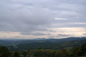
 Fall in Sky Meadows State Park | |
| Location | Delaplane, Virginia |
| Nearest city | Front Royal |
| Coordinates | 38°59′5″N 77°57′31″W / 38.98472°N 77.95861°W |
| Area | 1862 acres (754 ha) |
| Established | 1975 |
| Governing body | Virginia Department of Conservation and Recreation |
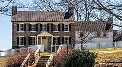
Mt. Bleak-Skye Farm | |
 Visitor Center at Mt Bleak-Skye Farm, April 2013 | |
| Location | 11012 Edmonds Ln., near Delaplane, Virginia |
| Area | 1,618.3 acres (654.9 ha) |
| Built | c. 1780 |
| Architectural style | Federal, Vernacular |
| NRHP reference No. | 04000552[1] |
| VLR No. | 030-0283 |
| Significant dates | |
| Added to NRHP | May 24, 2004 |
| Designated VLR | March 17, 2004[2] |
Sky Meadows State Park is a 1,862-acre (754 ha) park in the Virginia state park system. It is located in extreme northwest Fauquier County, Virginia in the Blue Ridge Mountains, near Paris, Virginia. It is about an hour outside of the Washington, D.C. metro region.
- ^ "National Register Information System". National Register of Historic Places. National Park Service. July 9, 2010.
- ^ "Virginia Landmarks Register". Virginia Department of Historic Resources. Archived from the original on September 21, 2013. Retrieved June 5, 2013.
© MMXXIII Rich X Search. We shall prevail. All rights reserved. Rich X Search


