Back سميثفيلد (رود آيلاند) Arabic بلده سميثفيلد ARZ Smithfield (Rhode Island) Catalan Смитфилд (Род-Айленд) CE Smithfield (lungsod sa Tinipong Bansa, Rhode Island) CEB Smithfield, Rhode Island Welsh Smithfield (Rhode Island) German Smithfield (Rod-Insulo) Esperanto Smithfield (Rhode Island) Spanish Smithfield (Rhode Island) Basque
Smithfield, Rhode Island | |
|---|---|
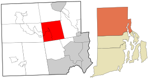
 Location in Providence County and the state of Rhode Island. | |
| Coordinates: 41°55′18″N 71°32′58″W / 41.92167°N 71.54944°W | |
| Country | United States |
| State | Rhode Island |
| County | Providence |
| Incorporated | 1731 |
| Named for | Smithfield, London |
| Government | |
| • Type | Council-manager |
| • Town Council | T. Michael Lawton (D) Sean M. Kilduff (D) Michael P. Iannotti (R) Rachel S. Toppi (R) John J. Tassoni Jr. (I) |
| • Town Manager | Randy Rossi |
| Area | |
| • Total | 27.8 sq mi (71.9 km2) |
| • Land | 26.6 sq mi (68.9 km2) |
| • Water | 1.2 sq mi (3.1 km2) |
| Elevation | 367 ft (112 m) |
| Population (2020) | |
| • Total | 22,118 |
| • Density | 831.5/sq mi (311.0/km2) |
| Time zone | UTC−5 (Eastern (EST)) |
| • Summer (DST) | UTC−4 (EDT) |
| ZIP Codes | 02828, 02917, 02814 |
| Area code | 401 |
| FIPS code | 44-66200[2] |
| GNIS feature ID | 1219817[1] |
| Website | smithfieldri.com |
Smithfield is a town that is located in Providence County, Rhode Island, United States. It includes the historic villages of Esmond, Georgiaville, Mountaindale, Hanton City, Stillwater and Greenville. The population was 22,118 at the 2020 census. Smithfield is the home of Bryant University, a private four year college.
- ^ a b U.S. Geological Survey Geographic Names Information System: Smithfield, Rhode Island
- ^ "U.S. Census website". United States Census Bureau. Retrieved January 31, 2008.
© MMXXIII Rich X Search. We shall prevail. All rights reserved. Rich X Search

