| Solomon Islands rain forests | |
|---|---|
 Makira Island | |
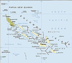
 The Solomon Islands archipelago, with the nation Solomon Islands in beige and Bougainville (a part of Papua New Guinea) in dun. | |
| Ecology | |
| Realm | Australasia |
| Biome | Tropical and subtropical moist broadleaf forests |
| Geography | |
| Area | 42,976 km2 (16,593 sq mi) |
| Countries | |
| Autonomous region of Papua New Guinea | Bougainville |
| Elevation | 0 - 2635 meters |
| Conservation | |
| Conservation status | vulnerable |
| Global 200 | Solomons-Vanuatu-Bismarck moist forests |
| Protected | 662 km2 (2%)[1] |
The Solomon Islands rain forests are a terrestrial ecoregion covering the Solomon Islands archipelago.[2][3][4]
- ^ Eric Dinerstein, David Olson, et al. (2017). An Ecoregion-Based Approach to Protecting Half the Terrestrial Realm, BioScience, Volume 67, Issue 6, June 2017, Pages 534–545; Supplemental material 2 table S1b. [1]
- ^ "Map of Ecoregions 2017". Resolve. Retrieved August 20, 2021.
- ^ "Solomon Islands rain forests". Digital Observatory for Protected Areas. Retrieved August 20, 2021.
- ^ "Solomon Islands rain forests". The Encyclopedia of Earth. Retrieved August 20, 2021.
© MMXXIII Rich X Search. We shall prevail. All rights reserved. Rich X Search
