Back Ägäischer Vulkanbogen ALS Arc volcànic del sud de l'Egeu Catalan Kykladský vulkanický oblouk Czech Kykladenbogen German Ελληνικό ηφαιστειακό τόξο Greek Հարավեգեյան հրաբխային աղեղ Armenian Arco vulcanico dell'Egeo meridionale Italian Јужноегејски Вулкански Лак Macedonian
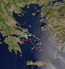
 The arc is shown by the green line. Along it are dozens of volcanic hot spots. A few are denoted in red. | |
 | |
| Country | Greece, Turkey |
|---|---|
| Region | South Aegean Sea |
| Coordinates | 36°25′00″N 25°26′00″E / 36.4167°N 25.4333°EThose of Santorini, located at about the center of the arc. |
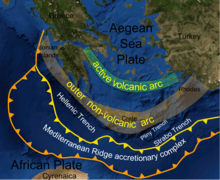
The South Aegean Volcanic Arc is a volcanic arc (chain of volcanoes) in the South Aegean Sea formed by plate tectonics. The prior cause was the subduction of the African Plate beneath the Eurasian Plate, raising the Aegean arc across what is now the North Aegean Sea. It was not yet the sea, nor an arc, or at least not the one it is today, nor was there a chain of volcanoes. In the Holocene, the process of back-arc extension began, probably stimulated by pressure from the Arabian Plate compressing the region behind the arc. The extension deformed the region into its current configuration. First, the arc moved to the south and assumed its arcuate configuration. Second, the Aegean Sea opened behind the arc because the crust was thinned and weakened there. Third, magma broke through the thinned crust to form a second arc composed of a volcanic chain. And finally, the Aegean Sea Plate broke away from Eurasia in the new fault zone to the north.
The extension is still ongoing. The current southern Aegean is one of the most rapidly deforming regions of the Himalayan-Alpine mountain belt. It is approximately 450 km long and 20 km to 40 km wide and runs from the Isthmus of Corinth on the Greek mainland to the Bodrum peninsula on the Turkish mainland.
© MMXXIII Rich X Search. We shall prevail. All rights reserved. Rich X Search