Back جنوب بوسطن ARZ گونئی بوستون AZB South Boston (bahin nga lungsod) CEB South Boston German بوستون جنوبی Persian South Boston Finnish South Boston French South Boston Italian 南波士頓 Chinese
South Boston | |
|---|---|
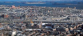
 South Boston from the air in 2010 | |
| Nickname: Southie | |
 | |
| Coordinates: 42°20′10″N 71°02′45″W / 42.33611°N 71.04583°W | |
| Country | United States |
| State | Massachusetts |
| County | Suffolk |
| Neighborhood of | Boston |
| Annexed by Boston | 1804 |
| Area | |
| • Land | 3.1 sq mi (8 km2) |
| Population (2010) | 33,688[1] |
| • Density | 10,867/sq mi (4,196/km2) |
| Time zone | UTC-5 (Eastern) |
| Zip Code | 02127 |
| Area code(s) | 617 / 857 |
South Boston (colloquially Southie) is a densely populated neighborhood of Boston, Massachusetts, United States, located south and east of the Fort Point Channel and abutting Dorchester Bay. It has undergone several demographic transformations since being annexed to the city of Boston in 1804. The neighborhood, once primarily farmland,[2] is popularly known by its twentieth century identity as a working class Irish Catholic community. Throughout the twenty-first century, the neighborhood has become increasingly popular with millennial professionals.
South Boston contains Dorchester Heights, where George Washington forced British troops to evacuate during the American Revolutionary War. South Boston has undergone gentrification, and consequently, its real estate market has seen property values join the highest in the city. South Boston has also left its mark on history with Boston busing desegregation. South Boston is also home to the St. Patrick's Day Parade, a celebration of the Irish-American culture and the Evacuation Day observance.
The headquarters of Reebok is in South Boston.
- ^ Department of Neighborhood Development, Policy Development & Research Division (n.d.). "South Boston Data Profile" (PDF). City of Boston. Archived (PDF) from the original on December 22, 2016. Retrieved April 11, 2022.
- ^ Simonds, Thomas C. (1857). History of South Boston :formerly Dorchester Neck, now ward XII of the city of Boston /. Boston. hdl:2027/yale.39002009629487.
© MMXXIII Rich X Search. We shall prevail. All rights reserved. Rich X Search
