Back باغاي الجنوبية Arabic Паўднёвы Пагай Byelorussian Pagai Selatan Catalan Pulau Pagai Selatan CEB Südpagai German Pagai del Sur Spanish Pagai do Sur Galician Pulau Pagai Selatan ID Pagai del sud Italian Pietų Pagajus Lithuanian
 | |
| Geography | |
|---|---|
| Location | South East Asia |
| Coordinates | 3°00′S 100°20′E / 3.000°S 100.333°E |
| Archipelago | Mentawai Islands |
| Area | 860.88 km2 (332.39 sq mi) |
| Administration | |
Indonesia | |
| Province | West Sumatra |
| Regency | Mentawai Islands |
| Demographics | |
| Population | 9,373 (2020 Census) |
| Pop. density | 10.9/km2 (28.2/sq mi) |
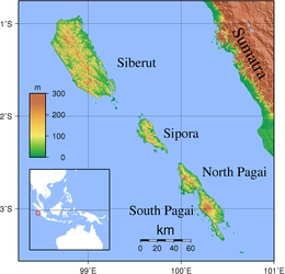
South Pagai (Indonesian: Pagai Selatan) is one of the Mentawai Islands of the west coast of Sumatra in Indonesia. The island is south of North Pagai (or Pagai Utara) Island. The population figure given for South Pagai (box to the right) refers to South Pagai District alone. The largely unpopulated south portion of Sikakap District covers the northern part of South Pagai Island, as well as various small islands in the strait between the two islands (the rest of Sikakap District, with most of its population, forms the southern part of North Pagai Island).
The September 2007 Sumatra earthquakes were located near these islands, producing coastal uplift, enlarging nearby islands and even producing six new ones.[1] The 2010 Mentawai earthquake and tsunami also struck off its southwest coast, causing a tsunami.
- ^ (in Japanese) Southern Sumatra Earthquake in 2007, coastal change, GSI Archived 2007-11-15 at the Wayback Machine
© MMXXIII Rich X Search. We shall prevail. All rights reserved. Rich X Search
