| Southeast Tibet shrub and meadows | |
|---|---|
 Flowering summer meadows in Luqu County in the eastern Tibetan Pleateau | |
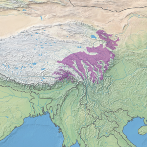
 Ecoregion territory (in purple) | |
| Ecology | |
| Realm | Palearctic |
| Biome | Montane grasslands and shrublands |
| Geography | |
| Area | 461,851 km2 (178,322 sq mi) |
| Countries | |
| Coordinates | 33°15′N 103°15′E / 33.25°N 103.25°E |
The Southeast Tibet shrub and meadows are a montane grassland ecoregion that cover the southeast and eastern parts of the Tibetan Plateau in China. The meadows in this region of Tibet are in the path of the monsoon rains and are wetter than the other upland areas of the Tibetan Plateau.[1] [2] [3] The "high cold" alpine terrain is one of high species diversity, due to the relatively high levels of precipitation for the region. Precipitation is lower in the northwest, and hence the vegetation thins from shrub to meadow or even desert.[3]
- ^ "Map of Ecoregions 2017". Resolve, using WWF data. Retrieved January 17, 2021.
- ^ "Southeast Tibet shrublands and meadows". Digital Observatory for Protected Areas. Retrieved January 17, 2021.
- ^ a b "Southeast Tibet shrub and meadows". The Encyclopedia of Earth. Retrieved January 17, 2021.
© MMXXIII Rich X Search. We shall prevail. All rights reserved. Rich X Search
