Back Spitsbergen Afrikaans سبيتسبرغن Arabic سبيتسبرجن ARZ Spitsbergen AST Qərbi Şpisbergen Azerbaijani Көнбайыш Шпицберген Bashkir Заходні Шпіцберген Byelorussian Шпицберген Bulgarian Spitsbergen Breton Spitsbergen Catalan
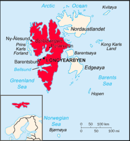
 Map of the Svalbard archipelago, with Spitsbergen emphasized in solid red. Inset shows the islands' place in Northern Europe. | |
 | |
| Geography | |
|---|---|
| Location | Arctic Ocean |
| Coordinates | 78°45′N 16°00′E / 78.750°N 16.000°E |
| Archipelago | Svalbard |
| Area | 37,673 km2 (14,546 sq mi) |
| Area rank | 36th |
| Highest elevation | 1,717 m (5633 ft)[1] |
| Highest point | Newtontoppen |
| Administration | |
Norway | |
| Largest settlement | Longyearbyen (pop. 2,417) |
| Demographics | |
| Population | 2,884 (2020) |
Spitsbergen (Urban East Norwegian: [ˈspɪ̀tsˌbærɡn̩]; formerly known as West Spitsbergen; Norwegian: Vest Spitsbergen or Vestspitsbergen [ˈvɛ̂stˌspɪtsbærɡn̩], also sometimes spelled Spitzbergen)[2][3][4][5] is the largest and the only permanently populated island of the Svalbard archipelago in northern Norway.
Constituting the westernmost bulk of the archipelago, it borders the Arctic Ocean, the Norwegian Sea and the Greenland Sea. Spitsbergen covers an area of 37,673 km2 (14,546 sq mi), making it the largest island in Norway and the 36th largest in the world. The administrative centre is Longyearbyen. Other settlements, in addition to research outposts, are the Russian mining community of Barentsburg, the research community of Ny-Ålesund, and the mining outpost of Sveagruva. Spitsbergen was covered in 21,977 km2 (8,485 sq mi) of ice in 1999, which was approximately 58.5% of the island's total area.
The island was first used as a whaling base in the 17th and 18th centuries, after which it was abandoned. Coal mining started at the end of the 19th century, and several permanent communities were established. The Svalbard Treaty of 1920 recognized Norwegian sovereignty and established Svalbard as a free economic zone and a demilitarized zone.
The Norwegian Store Norske and the Russian Arktikugol are the only mining companies at Spitsbergen. Research and tourism have become the important supplementary industries, featuring among others the University Centre in Svalbard and the Svalbard Global Seed Vault. No roads connect the settlements; instead snowmobiles, aircraft and boats serve as local transport. Svalbard Airport, Longyearbyen provides the main point of entry and exit.
The island has an Arctic climate, although with significantly higher temperatures than other places at the same latitude. The flora benefits from the long period of midnight sun, which compensates for the polar night. Svalbard is a breeding ground for many seabirds, and also supports polar bears, arctic foxes, reindeer and marine mammals. Six national parks protect the largely untouched, yet fragile environment. The island has many glaciers, mountains and fjords.
- ^ Scheffel, Richard L.; Wernet, Susan J., eds. (1980). Natural Wonders of the World. United States of America: Reader's Digest Association, Inc. p. 355. ISBN 0-89577-087-3.
- ^ "Of this Spitsbergen archipelago, the main island (the biggest) had the Norwegian name 'Vest Spitsbergen' ('West Spitsbergen' in English).” Umbreit, Spitsbergen (2009), p. ix.
- ^ "Spitsbergen… an Arctic archipelago… comprising the five large islands of West Spitsbergen…". Hugh Chisholm (ed.), Encyclopædia Britannica (1911), p. 708
- ^ ”… the Archipelago of Spitsbergen, comprising, with Bear Island… all the islands situated between 10deg. and 35deg. longitude East of Greenwich and between 74deg. and 81 deg. latitude North, especially West Spitsbergen…” Treaty concerning the Archipelago of Spitsbergen (1920), p. 1.
- ^ Berulfsen, Bjarne (1969). Norsk Uttaleordbok (in Norwegian). Oslo: H. Aschehoug & Co (W Nygaard). pp. 301, 356.
© MMXXIII Rich X Search. We shall prevail. All rights reserved. Rich X Search