Back مقاطعة سانت مارتن (لويزيانا) Arabic St. Martin Parish, Louisiana BAR সেন্ট মার্টিন পারিশ, লুইসিয়ানা BPY Séng Martin Gông (Louisiana) CDO Сент-Мартин (кӀошт, Луизиана) CE Saint Martin Parish CEB St. Martin Parish, Louisiana Welsh St. Martin Parish German Parroquia de St. Martin Spanish St. Martini vald Estonian
Saint Martin Parish | |
|---|---|
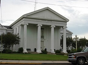
 St. Martin Parish Courthouse, St. Martinville | |
 Location within the U.S. state of Louisiana | |
 Louisiana's location within the U.S. | |
| Coordinates: 30°08′N 91°37′W / 30.13°N 91.61°W | |
| Country | |
| State | |
| Founded | 1811 |
| Named for | St. Martin |
| Seat | St. Martinville |
| Largest city | Breaux Bridge |
| Area | |
| • Total | 816 sq mi (2,110 km2) |
| • Land | 738 sq mi (1,910 km2) |
| • Water | 79 sq mi (200 km2) 9.7% |
| Population (2020) | |
| • Total | 51,767 |
| • Density | 63/sq mi (24/km2) |
| Time zone | UTC−6 (Central) |
| • Summer (DST) | UTC−5 (CDT) |
| Congressional district | 3rd |
| Website | www |
St. Martin Parish (French: Paroisse de Saint-Martin) is a parish located in the U.S. state of Louisiana, founded in 1811. Its parish seat is St. Martinville, and the largest city is Breaux Bridge.[1] At the 2020 census, the population was 51,767.[2] St. Martin Parish is part of the Lafayette metropolitan area in the region of Acadiana, along the Gulf Coast.
- ^ "Find a County". National Association of Counties. Retrieved June 7, 2011.
- ^ "QuickFacts: St. Martin Parish, Louisiana". United States Census Bureau.
© MMXXIII Rich X Search. We shall prevail. All rights reserved. Rich X Search