Back Staplehurst (lungsod sa Hiniusang Gingharian, Inglatera, Kent, lat 51,16, long 0,55) CEB Staplehurst Welsh Staplehurst Spanish استیپلهرست Persian Staplehurst French Staplehurst (Kent) Italian Staplehurst LLD Staplehurst (Kent) Dutch Staplehurst Polish Staplehurst, Kent Swedish
| Staplehurst | |
|---|---|
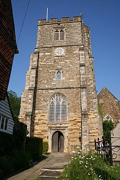
 All Saints' Church | |
Location within Kent | |
| Population | 6,003 (2001)[1]
5,947 (2011 Census)[2] |
| District | |
| Shire county | |
| Region | |
| Country | England |
| Sovereign state | United Kingdom |
| Post town | Tonbridge |
| Postcode district | TN12 |
| Dialling code | 01580 |
| Police | Kent |
| Fire | Kent |
| Ambulance | South East Coast |
| UK Parliament | |
Staplehurst /ˈsteɪpəlhɜːrst/ is a village and civil parish in the borough of Maidstone in Kent, England, 9 miles (14 km) south of the town of Maidstone and with a population of 6,003. The village lies on the route of a Roman road, which is now incorporated into the course of the A229. The name Staplehurst comes from the Old English 'stapol' meaning a 'post, pillar' and 'hyrst', as a 'wooded hill'; therefore, 'wooded-hill at a post',[3] a possible reference to a boundary marker at the position of All Saints' church atop the hill along the road from Maidstone to Cranbrook. The parish includes the hamlet of Hawkenbury.
- ^ "Staplehurst CP". Neighbourhood Statistics. Retrieved 20 August 2007.
- ^ "Civil Parish population 2011". Neighbourhood Statistics. Office for National Statistics. Retrieved 16 September 2016.
- ^ "History of Staplehurst - Kent Past". www.kentpast.co.uk. Retrieved 27 January 2021.
© MMXXIII Rich X Search. We shall prevail. All rights reserved. Rich X Search
