Back Steep (parokya) CEB Steep Welsh Steep Spanish استیپ (همپشر) Persian Steep (Royaume-Uni) French Steep (Hampshire) Italian Steep LLD Steep (Hampshire) Dutch Steep Polish Steep, Hampshire Swedish
| Steep | |
|---|---|
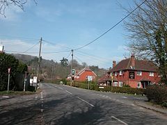
 Steep village centre during winter | |
Location within Hampshire | |
| Population | 1,391 (2011 census)[1] |
| OS grid reference | SU746253 |
| Civil parish |
|
| District | |
| Shire county | |
| Region | |
| Country | England |
| Sovereign state | United Kingdom |
| Post town | Petersfield |
| Postcode district | GU32 |
| Police | Hampshire and Isle of Wight |
| Fire | Hampshire and Isle of Wight |
| Ambulance | South Central |
| UK Parliament | |
Steep is a village and civil parish in the East Hampshire district of Hampshire, England. Its nearest town is Petersfield, which lies 1.4 miles (2.3 km) south of the village, just off the A3 road. The nearest railway station is Petersfield, at 1.6 miles (2.6 km) south of the village. It has two public houses, The Harrow and the Cricketers Inn, with the former being an 18th-century Grade II listed building. According to the 2011 census, it had a population of 1,391.
Iron Age and Roman remains have been found in the area. Steep formerly included two detached exclaves, the larger called Ambersham, which lay deep inside Sussex. These were two of the three detached portions of Hampshire in Sussex, and were annexed to that county when a new law came into effect in 1844. The church of All Saints was built around 1125. From medieval times, Steep was included in the parish of East Meon until it became an independent parish in 1867. Since 1899 the village has been the location of Bedales, a progressive public school.
- ^ "Civil Parish population 2011". Neighbourhood Statistics. Office for National Statistics. Retrieved 6 December 2016.
© MMXXIII Rich X Search. We shall prevail. All rights reserved. Rich X Search
