Back نهر ستيلاجواميش ARZ Riu Stillaguamish Catalan Stillaguamish River German Stillaguamish (rivero) Esperanto
| Stillaguamish River | |
|---|---|
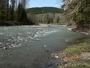
 The South Fork of the Stillaguamish River near Verlot | |
| Location | |
| Country | United States |
| State | Washington |
| Physical characteristics | |
| Source | North Cascades |
| • coordinates | 48°12′14″N 122°7′38″W / 48.20389°N 122.12722°W[1] |
| Mouth | Puget Sound |
• location | Port Susan |
• coordinates | 48°14′18″N 122°22′38″W / 48.23833°N 122.37722°W[1] |
• elevation | 0 m (0 ft) |
| Length | 67 mi (108 km)[2] |
| Basin size | 700 sq mi (1,800 km2) |
The Stillaguamish River is a river in the northwestern region of the U.S. state of Washington. It is mainly composed of two forks, the longer North Fork Stillaguamish (45 miles (72 km)) and the South Fork Stillaguamish. The two forks join near Arlington. From there the Stillaguamish River proper flows for 22 miles (35 km) to Puget Sound. The river's watershed drains part of the Cascade Range north of Seattle.
- ^ a b U.S. Geological Survey Geographic Names Information System: Stillaguamish River
- ^ Including North Fork
© MMXXIII Rich X Search. We shall prevail. All rights reserved. Rich X Search

