Back Stoke (munisipyo sa Kanada) CEB Stoke (Quebec) Basque استوک، کبک Persian Stoke (Québec) French Stoke (Québec) Italian Stoke, Québec Swedish
Stoke | |
|---|---|
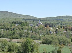
 Stoke's village | |
 Location within Le Val-Saint-François RCM | |
| Coordinates: 45°32′N 71°48′W / 45.533°N 71.800°W[1] | |
| Country | Canada |
| Province | Quebec |
| Region | Estrie |
| RCM | Le Val-Saint-François |
| Constituted | January 1, 1864 |
| Government | |
| • Mayor | Luc Cayer |
| • Federal riding | Compton—Stanstead |
| • Prov. riding | Mégantic |
| Area | |
| • Total | 252.90 km2 (97.65 sq mi) |
| • Land | 255.12 km2 (98.50 sq mi) |
| There is an apparent contradiction between two authoritative sources | |
| Population | |
| • Total | 3,014 |
| • Density | 11.8/km2 (31/sq mi) |
| • Pop 2016-2021 | |
| • Dwellings | 1,283 |
| Time zone | UTC−5 (EST) |
| • Summer (DST) | UTC−4 (EDT) |
| Postal code(s) | |
| Area code | 819 |
| Highways | |
| Website | stoke |
Stoke is a municipality in Le Val-Saint-François in the Estrie region of Quebec in Canada.
The Sentiers de l'Estrie hiking trails provide access to Mount Chapman, the highest peak of the Stoke Mountains, and Bald Peak, at an altitude of 650 metres (2,130 ft).
© MMXXIII Rich X Search. We shall prevail. All rights reserved. Rich X Search
