| Sulaiman Range alpine meadows | |
|---|---|
 | |
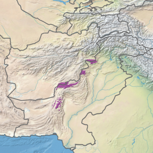
 Ecoregion territory (in purple) | |
| Ecology | |
| Realm | Palearctic |
| Biome | Montane grasslands and shrublands |
| Geography | |
| Area | 23,924 km2 (9,237 sq mi) |
| Country | Pakistan, Afghanistan |
| Coordinates | 32°45′N 69°45′E / 32.75°N 69.75°E |
The Sulaiman Range alpine meadows ecoregion (WWF ID: PA1018) covers a series of higher altitude mountain ranges along the crest of the Sulaiman Mountains, a southerly extension of the Hindu Kush Mountains along the Afghanistan-Pakistan border.[1][2][3][4] The area is relatively undeveloped, with about a third of the terrain either forested or in 'alpine steppe' shrub or herbaceous cover.[4]
- ^ "Sulaiman Range alpine meadows". World Wildlife Federation. Retrieved March 21, 2020.
- ^ "Map of Ecoregions 2017". Resolve, using WWF data. Retrieved September 14, 2019.
- ^ "Sulaiman Range alpine meadows". Digital Observatory for Protected Areas. Retrieved August 1, 2020.
- ^ a b "Sulaiman Range alpine meadows". The Encyclopedia of Earth. Retrieved August 28, 2020.
© MMXXIII Rich X Search. We shall prevail. All rights reserved. Rich X Search
