Back Survey of India German भारतीय सर्वेक्षण विभाग Hindi സർവേ ഓഫ് ഇന്ത്യ Malayalam भारतीय सर्वेक्षण विभाग Marathi Survey of India Dutch Survey of India SIMPLE இந்திய நில அளவைத் துறை Tamil సర్వే ఆఫ్ ఇండియా Tegulu
 | |
| Survey and mapping agency overview | |
|---|---|
| Formed | 1767[1] |
| Jurisdiction | Government of India |
| Headquarters | Hathibarkala Estate, New Cantt Road, Dehradun, Uttarakhand, India[2] |
| Minister responsible | |
| Survey and mapping agency executive |
|
| Parent department | Department of Science and Technology |
| Website | surveyofindia |


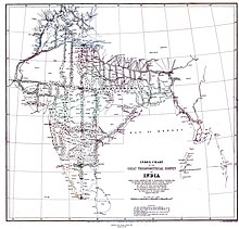
The Survey of India is India's central engineering agency in charge of mapping and surveying.[3] Set up in 1767[4] to help consolidate the territories of the British East India Company, it is one of the oldest Engineering Departments of the Government of India. Its members are from Survey of India Service cadre of Civil Services of India. It is headed by the Surveyor General of India. At present, the Surveyor General is Hitesh Kumar S. Makwana.
- ^ "About Us". Survey of India. Archived from the original on 26 May 2018. Retrieved 27 May 2018.
- ^ "Contact us". Survey of India. Archived from the original on 15 May 2018. Retrieved 27 May 2018.
- ^ On 250th birthday, Survey of India wants to shed its cloak of secrecy Archived 29 January 2017 at the Wayback Machine, Indian Express.
- ^ St. Peter Church Allahabad Archived 17 February 2023 at the Wayback Machine.
© MMXXIII Rich X Search. We shall prevail. All rights reserved. Rich X Search