Back مقاطعة سوتون (تكساس) Arabic Sutton County, Texas BAR Сатан (акруга) Byelorussian Сътън (окръг, Тексас) Bulgarian সাটন কাউন্টি, টেক্সাস BPY Sutton Gông (Texas) CDO Sutton County CEB Sutton County Czech Sutton County, Texas Welsh Sutton County German
Sutton County | |
|---|---|
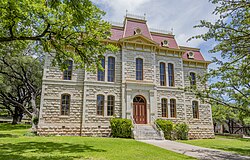
 The Sutton County Courthouse in Sonora | |
 Location within the U.S. state of Texas | |
 Texas's location within the U.S. | |
| Coordinates: 30°30′N 100°32′W / 30.5°N 100.54°W | |
| Country | |
| State | |
| Founded | 1890 |
| Named for | John S. Sutton |
| Seat | Sonora |
| Largest city | Sonora |
| Area | |
| • Total | 1,454 sq mi (3,770 km2) |
| • Land | 1,454 sq mi (3,770 km2) |
| • Water | 0.5 sq mi (1 km2) 0.03% |
| Population (2020) | |
| • Total | 3,372 |
| • Density | 2.3/sq mi (0.90/km2) |
| Time zone | UTC−6 (Central) |
| • Summer (DST) | UTC−5 (CDT) |
| Congressional district | 23rd |
| Website | www |


Sutton County is a county located on the Edwards Plateau in the U.S. state of Texas. As of the 2020 census, the population was 3,372.[1] Its county seat is Sonora.[2] The county was created in 1887 and organized in 1890.[3] Sutton County is named for John S. Sutton, an officer in the Confederate Army.
- ^ "Sutton County, Texas". United States Census Bureau. Retrieved February 23, 2021.
- ^ "Find a County". National Association of Counties. Retrieved June 7, 2011.
- ^ "Texas: Individual County Chronologies". Texas Atlas of Historical County Boundaries. The Newberry Library. 2008. Retrieved May 26, 2015.
© MMXXIII Rich X Search. We shall prevail. All rights reserved. Rich X Search