Back Swan Island (pulo sa Ostralya, State of Victoria) CEB Swan Island (Victoria) Italian Swan Island (ö i Australien, Victoria) Swedish
| Swan Island Victoria | |||||||||||||||
|---|---|---|---|---|---|---|---|---|---|---|---|---|---|---|---|
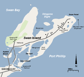
 Map of Swan Island | |||||||||||||||
| Postcode(s) | 3225 | ||||||||||||||
| Area | 1.40 km2 (0.5 sq mi) | ||||||||||||||
| LGA(s) | Borough of Queenscliffe | ||||||||||||||
| State electorate(s) | Bellarine | ||||||||||||||
| Federal division(s) | Corangamite | ||||||||||||||
| |||||||||||||||


Swan Island (Wathaurong: Woorang-a'look)[1] is a 1.4 km2 sand barrier island which, with Duck Island and the Edwards Point spit, separate Swan Bay from Port Phillip in Victoria, Australia. It lies close to and north of the town of Queenscliff at the eastern end of the Bellarine Peninsula, and is an official bounded locality of the Borough of Queenscliffe.
- ^ Clark, Ian D. (2002). Dictionary of Aboriginal placenames of Victoria. Melbourne: Victorian Aboriginal Corp. for Languages. p. 201. ISBN 0957936060.
© MMXXIII Rich X Search. We shall prevail. All rights reserved. Rich X Search