Back Taypa adası Azerbaijani তাইপা Bengali/Bangla Taipa Breton Taipa Catalan Tàng-giāng CDO Ilha da Taipa CEB Taipa Czech Taipa German Taipa Spanish Taipa French
Taipa (Nossa Senhora do Carmo)
氹仔 (嘉模堂區) | |
|---|---|
Area | |
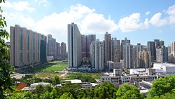
 Aerial view of Taipa | |
| Coordinates: 22°9′35″N 113°33′34″E / 22.15972°N 113.55944°E | |
| Freguesia | Freguesia de Nossa Senhora do Carmo |
| Concelho | Concelho das Ilhas (council abolished) |
| Country | |
| Sovereign state | |
| Area | |
| • Total | 7.9 km2 (3.1 sq mi) |
| Population (2021) | |
| • Total | 112,051 |
| • Density | 14,000/km2 (37,000/sq mi) |
| Time zone | UTC+8 (Macau Standard) |
| Taipa | |||||||||||||||||||||
|---|---|---|---|---|---|---|---|---|---|---|---|---|---|---|---|---|---|---|---|---|---|
| Chinese name | |||||||||||||||||||||
| Traditional Chinese | 氹仔 | ||||||||||||||||||||
| Simplified Chinese | 氹仔 | ||||||||||||||||||||
| Jyutping | Tam5zai2 | ||||||||||||||||||||
| |||||||||||||||||||||
| Portuguese name | |||||||||||||||||||||
| Portuguese | Taipa | ||||||||||||||||||||

Taipa (Chinese: 氹仔, Cantonese: [tʰɐ̌m.t͡sɐ̌i̯]; Portuguese: Taipa, pronounced [ˈtajpɐ]) is an area in Macau, connected to Coloane through the area known as Cotai, which is largely built from reclaimed land. Located on the northern half of the island, Taipa’s population is mostly suburban. Administratively, the boundaries of the traditional civil parish Freguesia de Nossa Senhora do Carmo are mostly coterminous with that of the former Taipa Island, except for a portion of the parish that lies on the island of Hengqin (Montanha), housing the campus of the University of Macau.
© MMXXIII Rich X Search. We shall prevail. All rights reserved. Rich X Search
