Back Тэхъутэмыкъое къедзыгъо ADY Taxtamukaysk rayonu Azerbaijani Тахтамукайскі раён Byelorussian Тахтамукайн кӀошт CE Takhtamukayskiy Rayon CEB Tahtamukay rayonı CRH Raión de Tajtamukái Spanish Tahtamukai rajoon Estonian شهرستان تختهموکایسکی Persian Tachtamukai (Distrikt) FRR
Takhtamukaysky District
Тахтамукайский район | |
|---|---|
| Other transcription(s) | |
| • Adyghe | Тэхъутэмыкъуае къедзыгъо |
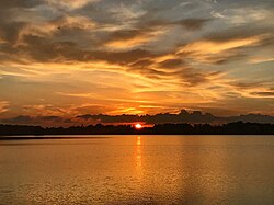
 Sunset in lake Starobzhegokaya, Takhtamukaysky District | |
 Location of Takhtamukaysky District in the Republic of Adygea | |
| Coordinates: 44°55′N 39°00′E / 44.917°N 39.000°E | |
| Country | Russia |
| Federal subject | Republic of Adygea[1] |
| Established | September 2, 1924 (first),[2] December 31, 1934 (second),[2] April 25, 1983 (third)[2] |
| Administrative center | Takhtamukay[1] |
| Government | |
| • Type | Local government |
| • Head[3] | Azmet Skhalyakho[3] |
| Area | |
| • Total | 463.6 km2 (179.0 sq mi) |
| Population | |
| • Total | 69,662 |
| • Density | 150/km2 (390/sq mi) |
| • Urban | 63.2% |
| • Rural | 36.8% |
| Administrative structure | |
| • Inhabited localities[6] | 2 Urban-type settlements[7], 25 rural localities |
| Municipal structure | |
| • Municipally incorporated as | Takhtamukaysky Municipal District[8] |
| • Municipal divisions[8] | 2 urban settlements, 5 rural settlements |
| Time zone | UTC+3 (MSK |
| OKTMO ID | 79630000 |
| Website | http://ta01.ru |
Takhtamukaysky District (Russian: Тахтамука́йский райо́н; Adyghe: Тэхъутэмыкъуае къедзыгъо) is an administrative[1] and a municipal[8] district (raion), one of the seven in the Republic of Adygea, Russia. It is located in the west of the republic and borders with Krasnoarmeysky District of Krasnodar Krai and with the territory of the City of Krasnodar in the north, Teuchezhsky District in the east, the territory of the Town of Goryachy Klyuch of Krasnodar Krai in the south, and with Seversky District of Krasnodar Krai in the south and west. The area of the district is 463.6 square kilometers (179.0 sq mi).[4] Its administrative center is the rural locality (an aul) of Takhtamukay.[1] At the 2010 Census, the total population of the district was 69,662, with the population of Takhtamukay accounting for 7.5% of that number.[5]
| Year | Pop. | ±% |
|---|---|---|
| 1959 | 34,322 | — |
| 1989 | 64,650 | +88.4% |
| 2002 | 65,674 | +1.6% |
| 2010 | 69,662 | +6.1% |
| 2021 | 122,759 | +76.2% |
| Source: Census data | ||
- ^ a b c d Law #171
- ^ a b c Cite error: The named reference
KubanATSwas invoked but never defined (see the help page). - ^ a b Official website of Takhtamukaysky District. Azmet Mezbechevich Skhalyakho, Head of Takhtamukaysky District (in Russian)
- ^ a b "Descriptive Statistics - Takhtamukaysky District" (in Russian). Federal State Statistics Service, Russian Federation. Retrieved July 2, 2016.
- ^ a b Russian Federal State Statistics Service (2011). Всероссийская перепись населения 2010 года. Том 1 [2010 All-Russian Population Census, vol. 1]. Всероссийская перепись населения 2010 года [2010 All-Russia Population Census] (in Russian). Federal State Statistics Service.
- ^ Cite error: The named reference
Countwas invoked but never defined (see the help page). - ^ The count of urban-type settlements may include the work settlements, the resort settlements, the suburban (dacha) settlements, as well as urban-type settlements proper.
- ^ a b c Law #220
- ^ "Об исчислении времени". Официальный интернет-портал правовой информации (in Russian). June 3, 2011. Retrieved January 19, 2019.
© MMXXIII Rich X Search. We shall prevail. All rights reserved. Rich X Search
