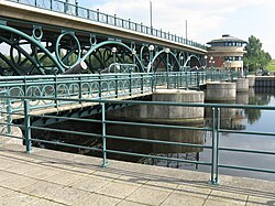
Tees Barrage | |
|---|---|
 View of the Tees barrage, bridge and footbridge from the upstream north bank | |
| Coordinates | 54°33′52″N 1°17′10″W / 54.5645°N 1.2862°W |
| Carries | Tees Barrage Way – pedestrians and cyclists use the footbridge (Teesdale Way) |
| Crosses | River Tees and Teesdale Way |
| Locale | Stockton-on-Tees, England, United Kingdom |
| Official name | Tees Barrage |
| Maintained by | Canal & River Trust |
| Website | canalrivertrust |
| Preceded by | Infinity Bridge |
| Followed by | Tees Viaduct |
| Characteristics | |
| Design | Arched viaduct |
| Material | Concrete, welded tubular steel and plate steel |
| Total length | 160 m |
| Longest span | 7.5 m |
| No. of spans | 8 |
| Piers in water | 3 |
| Load limit | 45 units of HB loading |
| Clearance below | 5 m (5.37 m in the lock) |
| Design life | 120 years |
| History | |
| Designer | Ove Arup and The Napper Partnership |
| Constructed by | Tarmac Construction |
| Fabrication by | Westbury Tubular Structures |
| Construction start | 4 November 1991 |
| Construction end | 1995 |
| Opened | 22 April 1995 |
| Inaugurated | 17 July 1995 |
| Statistics | |
| Daily traffic | very light |
| Location | |
 | |
The Tees Barrage is a barrage and road bridge across the River Tees, Northern England, just upriver of Blue House Point and is used to control the flow of the river, preventing flooding and the effects of tidal change. It is between the towns of Stockton-on-Tees and Thornaby, road access is only by the latter with limited road access to the Tees's north bank.
The Tees Barrage comprises a river barrage, road bridge, footbridge, barge lock, fish pass and access point to a white water course. The waters above the barrage are permanently held at the level of an average high tide and are used for watersports such as canoeing, jet skiing, dragonboat racing and incorporates a 1 km rowing course.
The Tees Barrage and Tees Barrage International White Water Course were developed by the defunct Teesside Development Corporation.
© MMXXIII Rich X Search. We shall prevail. All rights reserved. Rich X Search
