Back تلفورد، تنسی AZB Телфорд (Теннесси) CE Telford (lungsod sa Tinipong Bansa, Tennessee) CEB Telford (Tennessee) Spanish Telford (Tennessee) Basque تلفورد، تنسی Persian Telford (Tennessee) French Telford (Tennessee) Italian Telford (Tennessee) LLD Telford (Tennessee) Polish
Telford | |
|---|---|
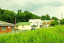
 Buildings along Mill Street | |
| Coordinates: 36°14′56″N 82°32′43″W / 36.24889°N 82.54528°W | |
| Country | United States |
| State | Tennessee |
| County | Washington |
| Area | |
| • Total | 2.47 sq mi (6.39 km2) |
| • Land | 2.47 sq mi (6.39 km2) |
| • Water | 0.00 sq mi (0.00 km2) |
| Elevation | 1,555 ft (474 m) |
| Population | |
| • Total | 909 |
| • Density | 368.46/sq mi (142.25/km2) |
| Time zone | UTC-5 (Eastern (EST)) |
| • Summer (DST) | UTC-4 (EDT) |
| ZIP code | 37690[3] |
| Area code | 423 |
| GNIS feature ID | 1304034[4] |
Telford is a census-designated place and unincorporated community in Washington County, Tennessee, located between Jonesborough and Limestone. As of the 2010 census, it had a population of 921.[5] The community is part of the Johnson City Metropolitan Statistical Area, which is a component of the Johnson City-Kingsport-Bristol, TN-VA Combined Statistical Area – commonly known as the "Tri-Cities" region. It has one school, Grandview Elementary.
- ^ "ArcGIS REST Services Directory". United States Census Bureau. Retrieved October 15, 2022.
- ^ "Census Population API". United States Census Bureau. Retrieved October 15, 2022.
- ^ United States Postal Service (2012). "USPS – Look Up a ZIP Code". Retrieved February 15, 2012.
- ^ "Telford". Geographic Names Information System. United States Geological Survey, United States Department of the Interior.
- ^ "U.S. Census website". United States Census Bureau. Retrieved May 14, 2011.
© MMXXIII Rich X Search. We shall prevail. All rights reserved. Rich X Search
