Back Telopea (bahin nga lungsod sa Ostralya) CEB تلوپی، نیو ساوت ولز Persian Telopea, New South Wales Romanian Telopea (del av en befolkad plats i Australien) Swedish
| Telopea Sydney, New South Wales | |||||||||||||||
|---|---|---|---|---|---|---|---|---|---|---|---|---|---|---|---|
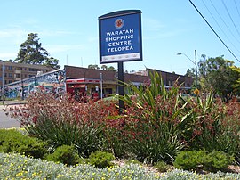
 Waratah Shopping Centre c. 2007 | |||||||||||||||
 | |||||||||||||||
| Population | 5,426 (2016 census)[1] | ||||||||||||||
| • Density | 3,620/km2 (9,370/sq mi) | ||||||||||||||
| Postcode(s) | 2117 | ||||||||||||||
| Elevation | 40 m (131 ft) | ||||||||||||||
| Area | 1.5 km2 (0.6 sq mi) | ||||||||||||||
| Location | 23 km (14 mi) north-west of Sydney CBD | ||||||||||||||
| LGA(s) | City of Parramatta | ||||||||||||||
| State electorate(s) | Epping | ||||||||||||||
| Federal division(s) | Parramatta | ||||||||||||||
| |||||||||||||||

Telopea /təloʊpiə/ is a suburb of Greater Western Sydney,[2] in the state of New South Wales, Australia. Telopea is located 23 kilometres north-west of the Sydney central business district, in the local government area of the City of Parramatta. The suburb is bordered by Kissing Point Road to the south and Pennant Hills Road to the north.
- ^ Australian Bureau of Statistics (27 June 2017). "Telopea(NSW)". 2016 Census QuickStats. Retrieved 12 August 2017.
- ^ Australia, Atlas of Living. "Species: Telopea". bie.ala.org.au.
© MMXXIII Rich X Search. We shall prevail. All rights reserved. Rich X Search