Back مقاطعة تنساس (لويزيانا) Arabic Tensas Parish, Louisiana BAR টেনসাস পারিশ, লুইসিয়ানা BPY Tensas Gông (Louisiana) CDO Тензас (кӀошт, Луизиана) CE Tensas Parish CEB Tensas Parish, Louisiana Welsh Tensas Parish German Parroquia de Tensas Spanish Tensasi vald Estonian
Tensas Parish | |
|---|---|
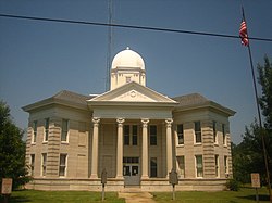
 Tensas Parish Courthouse at St. Joseph | |
 Location within the U.S. state of Louisiana | |
 Louisiana's location within the U.S. | |
| Coordinates: 32°00′N 91°20′W / 32°N 91.33°W | |
| Country | |
| State | |
| Founded | March 17, 1843 |
| Named for | Taensa people |
| Seat | St. Joseph |
| Largest town | Newellton |
| Area | |
| • Total | 641 sq mi (1,660 km2) |
| • Land | 603 sq mi (1,560 km2) |
| • Water | 38 sq mi (100 km2) 6.0% |
| Population (2020) | |
| • Total | 4,147 |
| • Density | 6.5/sq mi (2.5/km2) |
| Time zone | UTC−6 (Central) |
| • Summer (DST) | UTC−5 (CDT) |
| Congressional district | 5th |
| Website | louisiana |
Tensas Parish (French: Paroisse des Tensas) is a parish located in the northeastern section of the State of Louisiana; its eastern border is the Mississippi River. As of the 2020 census, the population was 4,147.[1] It is the least populated parish in Louisiana. The parish seat is St. Joseph.[2] The name Tensas is derived from the historic indigenous Taensa people.[3] The parish was founded in 1843 following Indian Removal.[4]
The parish was developed for cotton agriculture, which dominated the economy through the early 20th century. There has also been some cattle ranching in the 1930s and timber extraction.
- ^ "Census - Geography Profile: Tensas Parish, Louisiana". United States Census Bureau. Retrieved January 22, 2023.
- ^ "Find a County". National Association of Counties. Retrieved June 7, 2011.
- ^ Swanton, John Reed (1952). The Indian Tribes of North America. US Government Printing Office. p. 210. ISBN 978-0-8063-1730-4.
- ^ "Tensas Parish". Center for Cultural and Eco-Tourism. Retrieved September 5, 2014.
© MMXXIII Rich X Search. We shall prevail. All rights reserved. Rich X Search