Texas Gulf Coast
Beaches of Texas | |
|---|---|
Texas Pictorials of Gulf of Mexico Coast | |
| Coordinates: 28°23′05″N 96°23′02″W / 28.38477°N 96.38387°W | |
| Offshore water bodies | Gulf of Mexico |
| Area | |
| • Total | 2,149,760 acres (869,980 ha) |
| Dimensions | |
| • Length |
|
| Website | Texas Gulf Coast |
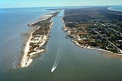
Texas Gulf Coast is an intertidal zone which borders the coastal region of South Texas, Southeast Texas, and the Texas Coastal Bend. The Texas coastal geography boundaries the Gulf of Mexico encompassing a geographical distance relative bearing at 367 miles (591 km) of coastline according to CRS[1] and 3,359 miles (5,406 km) of shoreline according to NOAA.[2]
- ^ "U.S. International Borders: Brief Facts", Congressional Research Service, November 9, 2006
- ^ "Shoreline Mileage of the United States" (PDF). NOAA Office for Coastal Management. National Oceanic and Atmospheric Administration.
© MMXXIII Rich X Search. We shall prevail. All rights reserved. Rich X Search


