Back سلسلة جبال ثانون ثونج تشاى ARZ Танентаўнджы Byelorussian Muntanyes de Thanon Thong Chai Catalan Cordillera Thanon Thong Chai Spanish Pegunungan Thanon Thong Chai ID Thanon Thong Chai Italian ტანენ-ტაუნჯი Georgian Танентаунджи Russian ทิวเขาถนนธงชัย Thai Танентаунджі Ukrainian
| Thanon Thong Chai Range Thanon Range / Tanen Taunggyi | |
|---|---|
| เทือกเขาถนนธงชัย | |
 The east side of the eastern Thanon Thong Chai Range rising above Chiang Mai airport | |
| Highest point | |
| Peak | Doi Inthanon |
| Elevation | 2,565 m (8,415 ft) |
| Coordinates | 18°35′16″N 98°29′13″E / 18.58778°N 98.48694°E |
| Dimensions | |
| Length | 170 km (110 mi) N/S |
| Width | 80 km (50 mi) E/W |
| Geography | |
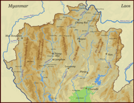
 Map of the Thai highlands
| |
| Country | Thailand |
| Provinces | Chiang Mai, Mae Hong Son and Lamphun |
| Parent range | Shan Hills |
| Geology | |
| Age of rock | Precambrian |
| Type of rock | Granite and limestone |


The Thanon Thong Chai Range (Thai: ทิวเขาถนนธงชัย, pronounced [tʰīw kʰǎw tʰānǒn tʰōŋ t͡ɕʰāj], formerly Thanon Range; Burmese Tanen Taunggyi)[1] is a mountain range in northern Thailand. Its tallest peak is Doi Inthanon, the highest point in Thailand. Most of the range is in Chiang Mai Province, with parts in Mae Hong Son and Lamphun Provinces.
Geologically in the Thanon Thong Chai Range, as in the other southern subranges of the Shan Hills, layers of alluvium are superimposed on hard rock. Precambrian rocks are present in this range, but absent in the ranges further east, such as the Khun Tan Range.[2]
- ^ North of Thailand Archived 2012-01-28 at the Wayback Machine
- ^ "Geology of Thailand". Department of Mineral Resources. Archived from the original on 1 December 2017. Retrieved 1 June 2019.
© MMXXIII Rich X Search. We shall prevail. All rights reserved. Rich X Search