Back Tharwa CEB Tharwa Italian Тарва Russian Tharwa Swedish Сарва (Австралійська столична територія) Ukrainian
| Tharwa Australian Capital Territory | |
|---|---|
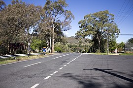
 Looking south-east, towards the Murrumbidgee River, on North Street in Tharwa. | |
| Coordinates | 35°30′49″S 149°04′10″E / 35.51361°S 149.06944°E |
| Population | 82 (2021 census)[1] |
| Established | 1862 |
| Postcode(s) | 2620 |
| Location | 35 km (22 mi) S of Canberra |
| District | Paddys River |
| Territory electorate(s) | Brindabella |
| Federal division(s) | |

Tharwa is a village in the district of Paddys River, in the Australian Capital Territory in Australia. It is situated on the southern side of the Australian Capital Territory, 35 kilometres (22 mi) south of Canberra. At the 2021 census, Tharwa had a population of 82.[1]
The village is located on the banks of the Murrumbidgee River and at the junction of Tidbinbilla and Naas Roads, and Tharwa Drive. The main public buildings are a general store, a preschool and primary school (now closed), Saint Edmund's Anglican Church, a cemetery, a community hall and tennis courts. The annual Tharwa Fair was hosted by the school, and was held in May until 2006. The Tharwa Fair is now organised by Tharwa Preschool.
- ^ a b Australian Bureau of Statistics (28 June 2022). "Tharwa". 2021 Census QuickStats. Retrieved 30 May 2023.
© MMXXIII Rich X Search. We shall prevail. All rights reserved. Rich X Search
