Back مديرية تتا Arabic থাট্টা জেলা Bengali/Bangla Thatta District CEB Thatta (Distrikt) German ناحیه تهته Persian District de Thatta French थट्टा जिला Hindi Distretto di Thatta Italian ਠੱਟਾ ਜ਼ਿਲ੍ਹਾ Punjabi Dystrykt Thatta Polish
Thatta District
| |
|---|---|
Top: Keenjhar Lake Bottom: Bhandore Fort | |
 | |
| Country | |
| Province | |
| Division | Hyderabad |
| Established | 1948 [1] |
| Headquarters | Thatta |
| Government | |
| • Type | District Administration |
| • Deputy Commissioner | N/A |
| • District Police Officer | N/A |
| • District Health Officer | N/A |
| Area | |
| • Total | 8,570 km2 (3,310 sq mi) |
| Population | |
| • Total | 1,083,191 |
| • Density | 130/km2 (330/sq mi) |
| Time zone | UTC+5 (PST) |
| Number of Tehsils | 7 |
| Website | [1] |
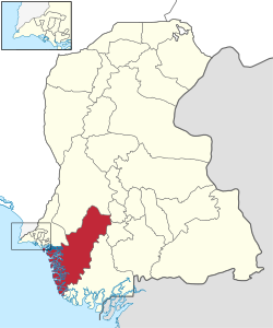
Thatta District (Sindhi: ٺٽو ضلعو, Urdu: ضلع ٹهٹہ) is located in the southern area, locally called Laar, of the province of Sindh, Pakistan. Its capital is Thatta. It is home to a large necropolis of Makli. In 2013, several talukas were separated to form the new Sujawal District.[3]
- ^ Habib, S; Naseer, F; RanaSaba, S; Jamil, Z; Bibi, R (17 December 2023). "A QUALITATIVE STUDY OF INFLUENTIAL FACTORS ON CAREER CHOICE IN NURSING AMONG FEMALE STUDENTS". Proceedings of the International Conference on Social Sciences. The International Institute of Knowledge Management. doi:10.17501/2357268x.2022.6201.
- ^ "Population of Thatta District per 2017 census" (PDF). Pakistan Bureau of Statistics, Government of Pakistan website. Archived from the original (PDF) on 27 January 2018. Retrieved 15 March 2023.
- ^ "Thatta Split to Make Sujawal 28th district of Sindh". Dawn (newspaper). Retrieved 4 April 2023.
© MMXXIII Rich X Search. We shall prevail. All rights reserved. Rich X Search

