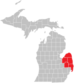
The Thumb | |
|---|---|
 The Thumb Counties highlighted in Red | |
| Location | Michigan, United States |
| Area | |
| • Total | 15,910 km2 (6,141 sq mi) |
| • Land | 10,270 km2 (3,966 sq mi) |
| • Water | 5,630 km2 (2,175 sq mi) |
The Thumb is a region and a peninsula of the U.S. state of Michigan, so named because the Lower Peninsula is shaped like a mitten. The Thumb area is generally considered to be in the Central Michigan region, east of the Flint area and the Tri-Cities and north of Metro Detroit. The region is also branded as the Blue Water Area.
The counties that constitute the Thumb form the peninsula that stretches northward into Lake Huron and Saginaw Bay. There is no formal list of which counties are part of the Thumb, but virtually all definitions include Huron, Tuscola, and Sanilac counties, and most include Lapeer and St. Clair counties. The population of the Thumb region as of the 2020 census was 370,617.
© MMXXIII Rich X Search. We shall prevail. All rights reserved. Rich X Search
