Back جبل ذا وريكين ARZ The Wrekin (bungtod sa Hiniusang Gingharian, lat 52,67, long -2,55) CEB Din Gwrygon Welsh The Wrekin French Rekinas Lithuanian The Wrekin Dutch The Wrekin Swedish
| The Wrekin | |
|---|---|
 | |
| Highest point | |
| Elevation | 407 metres (1,335 ft) |
| Prominence | 298 metres (978 ft) |
| Parent peak | Kinder Scout[1] |
| Listing | Marilyn |
| Geography | |
| Location | Shropshire, England |
| Parent range | Shropshire Hills |
| OS grid | SJ628080 |
| Topo map | OS Landranger 127 |
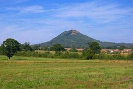
The Wrekin (/ˈriːkɪn/ REE-kin) is a hill in east Shropshire, England. It is located some five miles (8 km) west of Telford, on the border between the unitary authorities of Shropshire and Telford and Wrekin. Rising above the Shropshire Plain to a height of 407 metres (1,335 ft) above sea level, it is a prominent and well-known landmark, signalling the entrance to Shropshire for travellers westbound on the M54 motorway.[2] The Wrekin is contained within the northern salient of the Shropshire Hills AONB. The hill is popular with walkers and tourists and offers good views of Shropshire. It can be seen well into Staffordshire and the Black Country, and even as far as the Beetham Tower in Manchester, Winter Hill in Lancashire and Cleeve Hill in Gloucestershire.
© MMXXIII Rich X Search. We shall prevail. All rights reserved. Rich X Search