Back ثومبسونفيل (كونيتيكت) Arabic تامپسونویل، کنتیکت AZB Томпсонвилл (Коннектикут) CE Thompsonville (lungsod sa Tinipong Bansa, Connecticut) CEB Thompsonville, Connecticut Welsh Thompsonville (Connecticut) Spanish Thompsonville (Connecticut) Basque تامپسونویل، کنتیکت Persian Thompsonville (Connecticut) French Thompsonville (Connecticut) Italian
Thompsonville, Connecticut | |
|---|---|
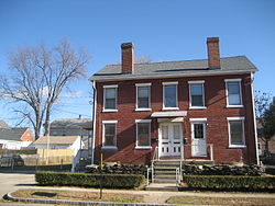
 Brick houses in Thompsonville | |
| Coordinates: 41°59′49″N 72°35′56″W / 41.99694°N 72.59889°W | |
| Country | United States |
| State | Connecticut |
| County | Hartford |
| Town | Enfield |
| Area | |
| • Total | 2.34 sq mi (6.06 km2) |
| • Land | 2.03 sq mi (5.27 km2) |
| • Water | 0.31 sq mi (0.79 km2) |
| Elevation | 115 ft (35 m) |
| Population (2010) | |
| • Total | 8,577 |
| • Density | 4,214/sq mi (1,627.1/km2) |
| Time zone | UTC-5 (Eastern) |
| • Summer (DST) | UTC-4 (Eastern) |
| ZIP code | 06082 |
| Area code | 860 |
| FIPS code | 09-75940 |
| GNIS feature ID | 2377873 |
Thompsonville is a census-designated place (CDP) in the town of Enfield in Hartford County, Connecticut, United States. The population of the CDP was 8,577 at the 2010 census.[1]
- ^ "Geographic Identifiers: 2010 Demographic Profile Data (G001): Thompsonville CDP, Connecticut". U.S. Census Bureau, American Factfinder. Archived from the original on February 12, 2020. Retrieved November 30, 2012.
© MMXXIII Rich X Search. We shall prevail. All rights reserved. Rich X Search

