Back Tigard, Oregon Afrikaans تيغارد Arabic تایقرد، اورقن AZB Тигърд (град, Орегон) Bulgarian Tigard Catalan Тайгард (Орегон) CE Tigard CEB Tigard, Oregon Welsh Tigard German Tigard Spanish
Tigard, Oregon | |
|---|---|
 Main Street in Downtown | |
| Motto: A Place to Call Home | |
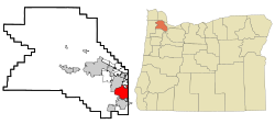
 Location in Oregon | |
| Coordinates: 45°25′30″N 122°46′44″W / 45.42500°N 122.77889°W | |
| Country | United States |
| State | Oregon |
| County | Washington |
| Incorporated | 1961 |
| Area | |
| • Total | 12.76 sq mi (33.04 km2) |
| • Land | 12.76 sq mi (33.03 km2) |
| • Water | 0.00 sq mi (0.01 km2) |
| Elevation | 240 ft (70 m) |
| Population | |
| • Total | 54,539 |
| • Density | 4,275.89/sq mi (1,650.99/km2) |
| Time zone | UTC-8 (Pacific) |
| • Summer (DST) | UTC-7 (Pacific) |
| ZIP codes | 97223, 97224, 97281 |
| Area code(s) | 503 and 971 |
| FIPS code | 41-73650 |
| GNIS feature ID | 2412069[2] |
| Website | City of Tigard |
Tigard (/ˈtaɪɡərd/ TY-gərd) is a city in Washington County, Oregon, United States. The population was 54,539 at the 2020 census, making it the 12th most populous city in Oregon. Incorporated in 1961, the city is located south of Beaverton and north of Tualatin, and is part of the Portland metropolitan area. Interstate 5 and Oregon Route 217 are the main freeways in the city, with Oregon Route 99W and Oregon Route 210 serving as other major highways. Public transit service is provided by TriMet, via several bus routes and the WES Commuter Rail line.
- ^ "ArcGIS REST Services Directory". United States Census Bureau. Retrieved October 12, 2022.
- ^ a b U.S. Geological Survey Geographic Names Information System: Tigard, Oregon
- ^ Cite error: The named reference
USCensusDecennial2020CenPopScriptOnlywas invoked but never defined (see the help page).
© MMXXIII Rich X Search. We shall prevail. All rights reserved. Rich X Search
