Back مقاطعة تيوغا (نيويورك) Arabic تیوقا بؤلگهسی، نیویورک AZB Tioga County, New York BAR Тайога (окръг, Ню Йорк) Bulgarian টিওগা কাউন্টি, নিউ ইয়র্ক BPY Tioga Gông (New York) CDO Тайога (гуо, Нью-Йорк) CE Tioga County (kondado sa Tinipong Bansa, New York) CEB Tioga County (New York) Czech Tioga County, Efrog Newydd Welsh
Tioga County | |
|---|---|
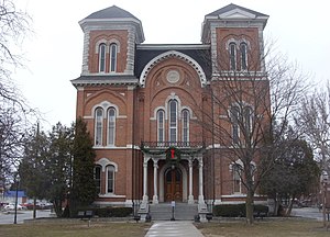
 Tioga County Courthouse | |
 Location within the U.S. state of New York | |
 New York's location within the U.S. | |
| Coordinates: 42°10′N 76°18′W / 42.17°N 76.30°W | |
| Country | |
| State | |
| Founded | 1791 |
| Seat | Owego |
| Largest village | Waverly |
| Area | |
| • Total | 523 sq mi (1,350 km2) |
| • Land | 519 sq mi (1,340 km2) |
| • Water | 4.3 sq mi (11 km2) 0.8% |
| Population (2020) | |
| • Total | 48,455 [1] |
| • Density | 93.4/sq mi (36.1/km2) |
| Time zone | UTC−5 (Eastern) |
| • Summer (DST) | UTC−4 (EDT) |
| Congressional districts | 22nd, 23rd |
| Website | www |
Tioga County /taɪˈoʊɡə/ is a county in the U.S. state of New York. As of the 2020 census, the population was 48,455.[2] Its county seat is Owego.[3] Tioga County is part of the Binghamton metropolitan area. The county is part of the Southern Tier region of the state.
The county's name is a corruption of Iroquois De-yoh-ho-gah, meaning "at the forks" or "where it forks."[4]
- ^ "US Census 2020 Population Dataset Tables for New York". United States Census Bureau. Retrieved January 2, 2022.
- ^ "U.S. Census Bureau QuickFacts: Tioga County, New York". United States Census Bureau. Retrieved January 2, 2022.
- ^ "Find a County". National Association of Counties. Archived from the original on May 31, 2011. Retrieved June 7, 2011.
- ^ Donehoo, G. P. (2019). A History of the Indian Villages and Place Names in Pennsylvania. United States: Papamoa Press.
© MMXXIII Rich X Search. We shall prevail. All rights reserved. Rich X Search

