Tirohanga | |
|---|---|
 Raphael House Rudolf Steiner School | |
 | |
| Coordinates: 41°11′58″S 174°54′25″E / 41.19944°S 174.90694°E | |
| Country | New Zealand |
| City | Lower Hutt City |
| Local authority | Hutt City Council |
| Electoral ward | Western |
| Area | |
| • Land | 118 ha (292 acres) |
| Population (June 2023)[2] | |
| • Total | 1,340 |
| Belmont | ||
|
|
Boulcott | |
| Harbour View | Melling, Lower Hutt CBD |
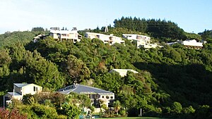
Tirohanga (Te Reo for "distant view") is a suburb of Lower Hutt City situated at the bottom of the North Island of New Zealand. The suburb is located on the western side of the Hutt River and State Highway 2.
- ^ Cite error: The named reference
Areawas invoked but never defined (see the help page). - ^ "Population estimate tables - NZ.Stat". Statistics New Zealand. Retrieved 25 October 2023.
© MMXXIII Rich X Search. We shall prevail. All rights reserved. Rich X Search
