Back Tolna ALS مقاطعة تولنا Arabic Tolna (medye) Azerbaijani Тольна (мэд’е) BE-X-OLD Толна Bulgarian Tolna Catalan Tolna megye CEB Tolna (župa) Czech Tolna Danish Komitat Tolna German
Tolna County
Tolna vármegye | |
|---|---|
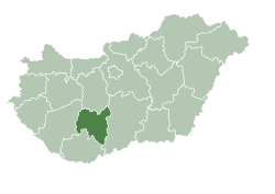
 Tolna County within Hungary | |
| Coordinates: 46°30′N 18°35′E / 46.500°N 18.583°E | |
| Country | Hungary |
| Region | Southern Transdanubia |
| County seat | Szekszárd |
| Districts | |
| Government | |
| • President of the General Assembly | Tamás Fehérvári (Fidesz-KDNP) |
| Area | |
| • Total | 3,703.16 km2 (1,429.80 sq mi) |
| • Rank | 15th in Hungary |
| Population (2018) | |
| • Total | 219,317[1] |
| • Rank | 18th in Hungary |
| GDP | |
| • Total | HUF 592 billion €1.900 billion (2016) |
| Postal code | 702x – 7252, 7352 – 7361 |
| Area code(s) | (+36) 74, 75 |
| ISO 3166 code | HU-TO |
| Website | www |
Tolna (Hungarian: Tolna vármegye, pronounced [ˈtolnɒ]; German: Komitat Tolnau) is an administrative county (comitatus or vármegye) in present-day Hungary as it was in the former Kingdom of Hungary. It lies in central Hungary, on the west bank of the river Danube. It shares borders with the Hungarian counties of Somogy, Fejér, Bács-Kiskun, and Baranya. The capital of Tolna county is Szekszárd. Its area is 3,703 km2.
- ^ nepesseg.com, population data of Hungarian settlements
- ^ Regions and Cities > Regional Statistics > Regional Economy > Regional GDP per Capita, OECD.Stats. Accessed on 16 November 2018.
© MMXXIII Rich X Search. We shall prevail. All rights reserved. Rich X Search


