Back তরঘার জেলা Bengali/Bangla ناحیه تور غر Persian District de Torghar French तोरग़र ज़िला Hindi Dystrykt Tor Ghar Polish ضلع کالا ڈھاکا PNB تور غر ولسوالۍ Pashto/Pushto Торгар (округ) Russian تورغر ضلعو Sindhi Kala Dhaka SIMPLE
Torghar District (formerly known as Kala Dhaka)
ضلع تورغر تور غر ولسوالۍ Kala Dhaka District ضلع کالا ڈهاکہ کالا ډاکه ولسوالۍ | |
|---|---|
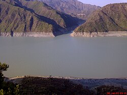
 Confluence of the Indus and Barndo Rivers | |
 Torghar District (red) in Khyber Pakhtunkhwa | |
| Coordinates: 34°36′49″N 72°47′18″E / 34.613573°N 72.788200°E | |
| Country | |
| Province | |
| Division | Hazara |
| Established | 2011 |
| Headquarters | Judba |
| Government | |
| • Type | District Administration |
| • Deputy Commissioner | Zia-ur-Rehman Marwat[1] |
| • District Police Officer | N/A |
| • District Health Officer | N/A |
| Area | |
| • Total | 497 km2 (192 sq mi) |
| Population (2023)[2] | |
| • Total | 200,445 |
| • Density | 400/km2 (1,000/sq mi) |
| Time zone | UTC+5 (PST) |
| Number of Tehsils | 3 |
| Website | torghar |
Torghar District (Pashto: تور غر ولسوالۍ, Urdu: ضلع تورغر) formerly known as Kala Dhaka (Hindko: کالا ڈهاکہ, English: Black Mountain) is a district in the Hazara Division of the Khyber Pakhtunkhwa province of Pakistan.[3] It was officially separated from Mansehra District in 2011 under Article 246 of the Constitution of the Islamic Republic of Pakistan.[4]
Primarily, Pashtuns dominate this area. The main Pashtun tribe of Torghar is Yusufzai, which constitutes more than half of the district population.
- ^ Yousaf, Iqra (3 January 2024). "Deputy Commissioner Torghar takes proactive measures to address health department issues". Associated Press of Pakistan. Retrieved 10 January 2024.
- ^ "District Wise Results / Tables (Census - 2023)" (PDF). www.pbscensus.gov.pk. Pakistan Bureau of Statistics.
- ^ "KP govt creates new Kohistan district". Dawn newspaper. 16 January 2014. Retrieved 10 July 2024.
- ^ Tor Ghar: Kala Dhaka becomes 25th K-P district The Express Tribune newspaper, 28 January 2011. Retrieved 10 July 2024
© MMXXIII Rich X Search. We shall prevail. All rights reserved. Rich X Search