Back نهر تورن ARZ تورن چایی AZB Турнеэльвен Byelorussian Торнеелвен Bulgarian Torne Breton Torne (rijeka) BS Tornionjoki CEB ڕووباری تۆرنیۆ CKB Torne Czech Torne älv Danish
| Torne river | |
|---|---|
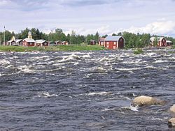
 The Torne at Kukkola rapids north of Tornio | |
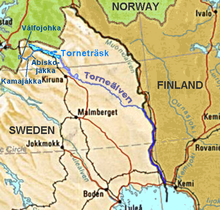
 Location of the Torne | |
| Location | |
| Countries | Norway (hydrological source) |
| Physical characteristics | |
| Source | Torne träsk and its main affluent |
| • location | Kiruna Municipality, Norrbotten, Sweden |
| • coordinates | 68°22′N 019°06′E / 68.367°N 19.100°E |
| • elevation | 341 m (1,119 ft)(hydrological source 1189 m 65°48′30″N 24°8′45″E / 65.80833°N 24.14583°E) |
| Mouth | Gulf of Bothnia |
• location | Tornio/Haparanda, Finland/Sweden |
• coordinates | 65°50′N 024°09′E / 65.833°N 24.150°E |
• elevation | 0 m (0 ft) |
| Length | 510 km (320 mi)[1] plus 110 km above the outlet of Torneträsk |
| Basin size | 40,157.1 km2 (15,504.7 sq mi)[2] |
| Discharge | |
| • average | 370 m3/s (13,000 cu ft/s)[1] |
The Torne, also known as the Tornio (Finnish: Tornionjoki, Swedish: Torne älv, Torneälven, Northern Sami: Duortneseatnu, Meänkieli: Väylä), is a river in northern Sweden and Finland. For approximately half of its length, it defines the border between these two countries. In the upper parts, the river is situated in Sweden before it meets the Muonio River where it adjoins the international border. It rises at the lake Torneträsk near the border with Norway and flows generally southeast for a distance of 522 kilometres (324 mi) into the Gulf of Bothnia. It is the largest river in Norrbotten County both by length and by watershed area.
At its source, the Torne is located close to the North Atlantic and Narvik on the other side of the watershed, with several thousands of kilometres between the locations via waterways.
- ^ a b "Torne älv". Nationalencyklopedin (in Swedish). Retrieved 14 July 2010. (subscription required)
- ^ "Län och huvudavrinningsområden i Sverige" (PDF) (in Swedish). Swedish Meteorological and Hydrological Institute. Retrieved 14 July 2010.
© MMXXIII Rich X Search. We shall prevail. All rights reserved. Rich X Search