| Torngat Mountain tundra | |
|---|---|
 | |
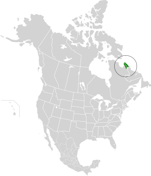
 Ecoregion territory (in green) | |
| Ecology | |
| Realm | Nearctic |
| Biome | Tundra |
| Geography | |
| Area | 32,363 km2 (12,495 sq mi) |
| Country | Canada |
| Coordinates | 58°45′N 64°30′W / 58.75°N 64.5°W |
The Torngat Mountain tundra ecoregion (WWF ID: NA1118) covers the Torngat Mountains on the northeastern tip of the Labrador Peninsula where the provinces of Quebec and Newfoundland and Labrador meet. The mountains feature glacially carved U-shaped valleys and deep fjords. The vegetation over most of the territory is that of arctic tundra (lichen, moss, sedges and grasses), herbaceous cover, or bare rock. The region supports seasonal polar bears, black bears, and caribou. The Atlantic coast is on the Atlantic Flyway for migratory birds.[1][2][3][4]
- ^ "Torngat Mountain tundra". World Wildlife Federation. Retrieved March 21, 2020.
- ^ "Map of Ecoregions 2017". Resolve, using WWF data. Retrieved September 14, 2019.
- ^ "Torngat Mountain tundra". Digital Observatory for Protected Areas. Retrieved August 1, 2020.
- ^ "Torngat Mountain tundra". The Encyclopedia of Earth. Retrieved August 28, 2020.
© MMXXIII Rich X Search. We shall prevail. All rights reserved. Rich X Search
