Back Liniennetzplan German نقشه ترانزیت Persian Peta transit ID 路線図 Japanese 노선도 Korean Lijnennetkaart Dutch Toplu taşıma haritası Turkish Схема маршрутів громадського транспорту Ukrainian 路線圖 Chinese
This article needs additional citations for verification. (April 2014) |
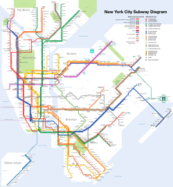
A transit map is a topological map in the form of a schematic diagram used to illustrate the routes and stations within a public transport system—whether this be bus, tram, rapid transit, commuter rail or ferry routes.[1] Metro maps, subway maps, or tube maps of metropolitan railways are some common examples.[2][3]
The primary function of a transit map is to facilitating the passengers' orientation and navigation, helping them to efficiently use the public transport system and identify which stations function as interchange between lines.[2]
Transit maps can usually be found in the transit vehicles, at the platforms or in printed timetables. They are also accessible through digital platforms like mobile apps and websites, ensuring widespread availability and convenience for passengers.[4][5]


Cite error: There are <ref group=lower-alpha> tags or {{efn}} templates on this page, but the references will not show without a {{reflist|group=lower-alpha}} template or {{notelist}} template (see the help page).
- ^ Hanniel, Iddo; Shai, Hirsch. "Topological Maps". doc.cgal.org. Archived from the original on June 1, 2023. Retrieved March 8, 2025.
- ^ a b Guo, Zhan (April 16, 2011). "Mind the map! The impact of transit maps on path choice in public transit". Transportation Research Part A: Policy and Practice. 45 (7): 625–639. Archived from the original on October 12, 2022 – via Elsevier Science Direct.
A transit map is a schematic diagram that depicts the locations, directions, and connections of stations and lines in a public transit system.
- ^ Prabhakar, Archana; Grison, Elise; Morgagni, Simone; Lhuillier, Simon (April 21, 2022). "Transit maps: do they shape our minds?" (PDF). 3rd Schematic Mapping Workshop. Archived from the original (PDF) on February 17, 2025 – via ResearchGate.
- ^ Tyler, Richard (February 12, 2025). "Blind inventor leads the way in the US capital". www.thetimes.com. Archived from the original on March 8, 2025. Retrieved March 8, 2025.
- ^ Matters, Transport for London | Every Journey. "Tube". Transport for London. Archived from the original on March 4, 2025. Retrieved March 8, 2025.
© MMXXIII Rich X Search. We shall prevail. All rights reserved. Rich X Search

