Back Tribhuvan Rajmarg German त्रिभुवन राजपथ DTY بزرگراه تریبووان Persian त्रिभुवन राजपथ MAI त्रिभुवन राजपथ Nepali Tribhuvan Highway NB ทางหลวงตริภูวัน Thai Шосе Трибхуван H02 Ukrainian 特里布萬公路 Chinese
| H02 | ||||
|---|---|---|---|---|
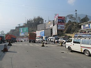
| Tribhuvan Highway, the first highway of Nepal | ||||
Tribhuvan Highway in red | ||||
 Tribhuvan Highway | ||||
| Route information | ||||
| Part of | ||||
| Maintained by MoPIT (Department of Roads) | ||||
| Length | 189 km (117 mi) | |||
| Major junctions | ||||
| From | Tripureshwor, Kathmandu, Nepal | |||
| To | Birgunj, Nepal | |||
| Location | ||||
| Country | Nepal | |||
| Highway system | ||||
| ||||

The Tribhuvan Highway or NH41 (previously: H02)(Nepali: त्रिभुवन राजपथ) connects the outskirts of Kathmandu, the capital of Nepal, with Birganj/Raxaul on the Nepal-India border.[1][2] NH 28 and NH 28A links Raxaul with Lucknow/Barauni and other locations in India.
- ^ "Highways in Nepal". Adarsha Nepal Adventure. Archived from the original on 3 July 2013. Retrieved 18 May 2010.
- ^ Woodhatch, Tom (1999). Nepal handbook. Footprint Handbooks. p. 431. ISBN 9781900949446. Retrieved 18 May 2010.
Tribhuvan Highway.
{{cite book}}:|work=ignored (help)
© MMXXIII Rich X Search. We shall prevail. All rights reserved. Rich X Search

