Back ترينكومالي Arabic ترينكومالى ARZ Трынкамалі Byelorussian Тринкомале Bulgarian ত্রিঙ্কোমালি Bengali/Bangla Trincomalee Breton Trincomalee Catalan Trincomalee (kapital sa lalawigan sa Sri Lanka) CEB Trincomalee Czech Trincomalee Danish
Trincomalee
திருகோணமலை ත්රිකුණාමලය | |
|---|---|
| City of Trincomalee | |
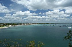
 View of Trincomalee Bay | |
 | |
| Coordinates: 8°34′0″N 81°14′0″E / 8.56667°N 81.23333°E | |
| Country | Sri Lanka |
| Province | Eastern |
| District | Trincomalee |
| DS Division | Town & Gravets |
| Government | |
| • Type | Urban Council |
| Area | |
| • Total | 7.5 km2 (2.9 sq mi) |
| Elevation | 8 m (26 ft) |
| Population (2012) | |
| • Total | 99,135 |
| • Density | 13,000/km2 (34,000/sq mi) |
| Demonym | Trincomalians |
| Time zone | UTC+5:30 (Sri Lanka Standard Time Zone) |
| • Summer (DST) | UTC+6 |
Trincomalee (English: /ˌtrɪŋkoʊməˈliː/; Tamil: திருகோணமலை, romanized: Tirukōṇamalai; Sinhala: ත්රිකුණාමළය, romanized: Trikuṇāmaḷaya), also known as Gokanna and Gokarna,[1] is the administrative headquarters of the Trincomalee District and major resort port city of Eastern Province, Sri Lanka. Located on the east coast of the island overlooking the Trincomalee Harbour, Trincomalee has been one of the main centres of Sri Lankan Tamil speaking culture on the island for nearly a millennium.[2] With a population of 99,135,[3] the city is built on a peninsula of the same name, which divides its inner and outer harbours. It is home to the famous Koneswaram temple from where it developed and earned its historic Tamil name Thirukonamalai. The town is home to other historical monuments such as the Bhadrakali Amman Temple, Trincomalee, the Trincomalee Hindu Cultural Hall and, opened in 1897, the Trincomalee Hindu College. Trincomalee is also the site of the Trincomalee railway station and an ancient ferry service to Jaffna and the south side of the harbour at Muttur.
Trincomalee was made into a fortified port town following the Portuguese conquest of the Jaffna kingdom, changing hands between the Danish in 1620, the Dutch, the French following a battle of the American Revolutionary War and the British in 1795, being absorbed into the British Ceylon state in 1815. The city's architecture shows some of the best examples of interaction between native and European styles. Attacked by the Japanese as part of the Indian Ocean raid during World War II in 1942, the city and district were affected after Sri Lanka gained independence in 1948, when the political relationship between Tamil and Sinhalese people deteriorated, erupting into civil war. It is home to major naval and air force bases at the Trincomalee Garrison. The city also has the largest Dutch fort on the island.
The Trincomalee Bay, bridged by the Mahavilli Ganga River to the south, the historical "Gokarna" in Sanskrit, means "Cow's Ear", akin to other sites of Siva worship across the Indian subcontinent. Uniquely, Trincomalee is a Pancha Ishwaram, a Paadal Petra Sthalam, a Maha Shakti Peetha and Murugan Tiruppadai of Sri Lanka; its sacred status to the Hindus has led to it being declared "Dakshina-Then Kailasam" or "Mount Kailash of the South" and the "Rome of the Pagans of the Orient". The harbour is renowned for its large size and security; unlike any other in the Indian Ocean, it is accessible in all weathers to all craft. It has been described as the "finest harbour in the world" and by the British, "the most valuable colonial possession on the globe, as giving to our Indian Empire a security which it had not enjoyed from elsewhere".
- ^ "Trincomalee – Sri Lanka". britannica.com. Retrieved 31 March 2018.
- ^ Gunasingam, Selladurai (1979). The Tamils and Trincomalee (PDF). Jaffna: Aseeravatham Press. p. 1-30.
- ^ "Sri Lanka: largest cities and towns and statistics of their population". World Gazetteer.[dead link]
© MMXXIII Rich X Search. We shall prevail. All rights reserved. Rich X Search
