| Trinidad mangroves | |
|---|---|
 | |
 Ecoregion territory (in red) | |
| Ecology | |
| Realm | Neotropic |
| Biome | Mangroves |
| Geography | |
| Area | 259 km2 (100 sq mi) |
| Country | Trinidad and Tobago |
| Coordinates | 10°25′N 61°03′W / 10.42°N 61.05°W |
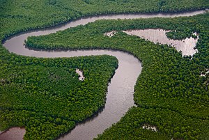
The Trinidad mangroves ecoregion (WWF ID: NT1436) covers the separate mangrove forest areas on the coast of the island of Trinidad, in the country of Trinidad and Tobago. The character of the mangroves is affected by the large amount of fresh water flowing out of the Orinoco River and Amazon River to the south, which flow northwest around the island. The mangroves of Trinidad are found on all coasts, and are usually in the estuaries of rivers, but also found in coastal lagoons.[1][2][3]
- ^ "Trinidad mangroves". World Wildlife Federation. Retrieved November 20, 2020.
- ^ "Map of Ecoregions 2017". Resolve, using WWF data. Retrieved November 20, 2020.
- ^ "Trinidad mangroves". The Encyclopedia of Earth. Retrieved November 20, 2020.
© MMXXIII Rich X Search. We shall prevail. All rights reserved. Rich X Search
