Tuamarina | |
|---|---|
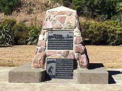
 Pioneers' Memorial in Tuamarina | |
 | |
| Coordinates: 41°25′49″S 173°57′44″E / 41.43028°S 173.96222°E | |
| Country | New Zealand |
| Region | Marlborough |
| Ward |
|
| Electorates | |
| Government | |
| • Territorial Authority | Marlborough District Council |
| • Marlborough District Mayor | Nadine Taylor |
| • Kaikōura MP | Stuart Smith |
| • Te Tai Tonga MP | Tākuta Ferris |
| Area | |
| • Total | 9.68 km2 (3.74 sq mi) |
| Population (June 2023)[2] | |
| • Total | 230 |
| • Density | 24/km2 (62/sq mi) |
| Postcode(s) | 7273 |
Tuamarina (often spelled Tua Marina) is a small town in Marlborough, New Zealand. State Highway 1 runs through the area. The Tuamarina River joins the Wairau River just south of the settlement. Picton is about 18 km to the north, and Blenheim is about 10 km to the south.[3][4]
The name is a corruption of the Māori word Tuamarino, which means 'the calm beyond'. Dairy farming is the major economic activity,.The original Factory was the Waitohi Co-op which amalgamated with the Koromiko cheese factory and the Rai Valley Co-op to form the Marlborough Cheese Company in 1981. The new Company continued Waitohi's long history winning a number of awards[5] Marlborough Cheese was taken over by Fonterra Dairy Company in 1999. it was destroyed by fire in 2004.
The Wairau Affray occurred in the area in 1843, resulting in 26 deaths.[6]
The Wairau Plain is prone to flooding, and river conservation is necessary to keep the river under control. Significant floods have occurred in the Tuamarina area, such as one in December 1939.[7]
- ^ Cite error: The named reference
Areawas invoked but never defined (see the help page). - ^ "Subnational population estimates (RC, SA2), by age and sex, at 30 June 1996-2023 (2023 boundaries)". Statistics New Zealand. Retrieved 25 October 2023. (regional councils); "Subnational population estimates (TA, SA2), by age and sex, at 30 June 1996-2023 (2023 boundaries)". Statistics New Zealand. Retrieved 25 October 2023. (territorial authorities); "Subnational population estimates (urban rural), by age and sex, at 30 June 1996-2023 (2023 boundaries)". Statistics New Zealand. Retrieved 25 October 2023. (urban areas)
- ^ Peter Dowling, ed. (2004). Reed New Zealand Atlas. Reed Books. pp. map 61. ISBN 0-7900-0952-8.
- ^ Roger Smith, GeographX (2005). The Geographic Atlas of New Zealand. Robbie Burton. pp. map 139. ISBN 1-877333-20-4.
- ^ "Tuamarina". Marlborough Online.
- ^ "Wairau Affray". Encyclopedia of New Zealand (1966).
- ^ McIntosh, Alister; Redman, William Edward; Allen, William Raymond, eds. (1940). Marlborough: A Provincial History. Blenheim: Marlborough Provincial Historical Committee. pp. 367f.
© MMXXIII Rich X Search. We shall prevail. All rights reserved. Rich X Search
