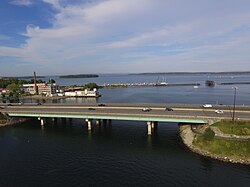
Tukey's Bridge | |
|---|---|
 Tukey's Bridge from the west, above Back Cove | |
| Coordinates | 43°40′35″N 70°15′23″W / 43.6763°N 70.2565°W |
| Carries | Eight auto lanes; |
| Crosses | Back Cove |
| Locale | Portland, Maine |
| History | |
| Opened | 1960 |
| Location | |
 | |
Tukey's Bridge is a bridge connecting the neighborhoods of Munjoy Hill and East Deering in Portland, Maine. It is part of Interstate 295, U.S. Route 1, and Washington Avenue (State Route 26).
Back Cove Trail crosses the bridge on its western side.
© MMXXIII Rich X Search. We shall prevail. All rights reserved. Rich X Search
