Back قمم التوأم (سان فرانسيسكو) Arabic Туин Пийкс (квартал на Сан Франциско) Bulgarian Twin Peaks (San Francisco) BS Twin Peaks (bukid sa Tinipong Bansa, California, San Francisco County, lat 37,75, long -122,45) CEB Twin Peaks (San Francisco) German Twin Peaks (San Francisco) French ツインピークス Japanese Twin Peaks (San Francisco) Dutch Twin Peaks (San Francisco) Romanian Твин-Пикс (Сан-Франциско) Russian
| Twin Peaks | |
|---|---|
 The Twin Peaks | |
 | |
| Type | Municipal (San Francisco) |
| Location | San Francisco |
| Area | 34 acres (14 ha) |
| Operated by | San Francisco Recreation & Parks |
| Status | Open all year |
| Highest point | |
| Elevation | 925 ft (282 m) NAVD 88[1] |
| Listing | San Francisco Hill |
| Coordinates | 37°45′06″N 122°26′52″W / 37.751586275°N 122.447721511°W[2] |
| Geography | |
| Location | San Francisco, California, U.S. |
| Topo map | USGS San Francisco North |
| Climbing | |
| Easiest route | Paved road, hike |
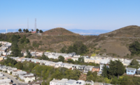
The Twin Peaks are two prominent hills with an elevation of about 925 feet (282 m)[1] located near the geographic center of San Francisco, California. The Twin Peaks are the second and third highest mountains in the city; only 928 foot (283 m) Mount Davidson is higher within San Francisco city limits.[3]
- ^ a b "Twin Peaks, California". Peakbagger.com. Retrieved 2009-02-27.
- ^ "South Twin 2". NGS Data Sheet. National Geodetic Survey, National Oceanic and Atmospheric Administration, United States Department of Commerce.
- ^ San Francisco Recreation and Parks Department (2006). "Twin Peaks" Archived 2007-09-30 at the Wayback Machine, section 6.8 of Significant Natural Resources Areas Management Plan Archived 2008-03-14 at the Wayback Machine. Retrieved April 21, 2007.
© MMXXIII Rich X Search. We shall prevail. All rights reserved. Rich X Search
