| Tygart Valley River | |
|---|---|
 The Tygart Valley River at the mouth of the Buckhannon River (just above center). Photo taken along the B&O Railroad between Belington and Philippi. | |
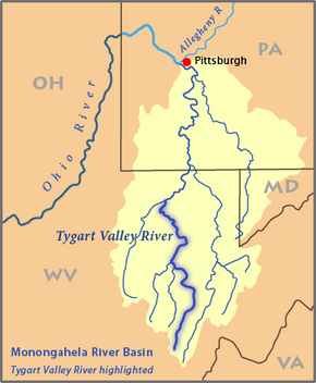
 Map of the Monongahela River basin, with the Tygart Valley River highlighted | |
| Location | |
| Country | United States |
| State | West Virginia |
| Counties | Barbour, Marion, Pocahontas, Taylor, Randolph |
| Physical characteristics | |
| Source | Allegheny Mountains |
| • location | Pocahontas County, WV |
| • coordinates | 38°28′06″N 79°58′51″W / 38.46833°N 79.98083°W[1] |
| • elevation | 4,540 ft (1,380 m)[2] |
| Mouth | Monongahela River |
• location | Fairmont, WV |
• coordinates | 39°27′54″N 80°09′11″W / 39.46500°N 80.15306°W[1] |
• elevation | 863 ft (263 m)[1] |
| Length | 135 mi (217 km)[3] |
| Basin size | 1,329 sq mi (3,440 km2)[4] |
| Discharge | |
| • location | mouth |
| • average | 2,855.07 cu ft/s (80.847 m3/s) (estimate)[5] |
| Basin features | |
| Tributaries | |
| • left | Middle Fork River, Buckhannon River |
| • right | Conley Run |


The Tygart Valley River — also known as the Tygart River — is a principal tributary of the Monongahela River, approximately 135 miles (217 km) long,[3] in east-central West Virginia in the United States. Via the Monongahela and Ohio rivers, it is part of the watershed of the Mississippi River, draining an area of 1,329 square miles (3,440 km2) in the Allegheny Mountains and the unglaciated portion of the Allegheny Plateau.
- ^ a b c Geographic Names Information System. "Geographic Names Information System entry for Tygart Valley River (Feature ID #1553309)". Retrieved 2007-03-12.
- ^ Google Earth elevation for GNIS source coordinates. Retrieved on March 12, 2007.
- ^ a b U.S. Geological Survey. National Hydrography Dataset high-resolution flowline data. The National Map, accessed August 15, 2011
- ^ Rice, Donald L. (2006). "Tygart Valley River". In Ken Sullivan (ed.). The West Virginia Encyclopedia. Charleston, W.Va.: West Virginia Humanities Council. p. 721. ISBN 0-9778498-0-5.
- ^ United States Environmental Protection Agency. "Watershed Report: Tygart Valley River". watersgeo.epa.gov. Archived from the original on 2021-07-03. Retrieved 2021-07-03.
© MMXXIII Rich X Search. We shall prevail. All rights reserved. Rich X Search
