Back Unity Township, Pennsylvania Welsh Municipio de Unity (Pensilvania) Spanish Юніті Тауншип (округ Вестморленд, Пенсільванія) Ukrainian Xã Unity, Quận Westmoreland, Pennsylvania Vietnamese
Unity Township, Pennsylvania | |
|---|---|
 Township office, Beatty County Road and Beatty Village Road | |
 Map of Westmoreland County, Pennsylvania Highlighting Unity Township | |
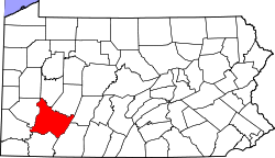
 Map of Pennsylvania highlighting Westmoreland County | |
| Country | United States |
| State | Pennsylvania |
| County | Westmoreland |
| Settled | 1760 |
| Incorporated | September 23, 1789 |
| Area | |
| • Total | 67.58 sq mi (175.02 km2) |
| • Land | 67.44 sq mi (174.67 km2) |
| • Water | 0.14 sq mi (0.35 km2) |
| Population | |
| • Total | 21,724 |
| • Estimate (2021)[2] | 21,599 |
| Time zone | UTC-5 (Eastern (EST)) |
| • Summer (DST) | UTC-4 (EDT) |
| Area code | 724 |
| FIPS code | 42-129-78656 |
| Website | Official website |
Unity Township is a township in Westmoreland County, Pennsylvania, United States. The population was 21,724 at the 2020 census,[2] a decline of approximately 4% compared to the 2010 census.
The township is home to Saint Vincent Archabbey, College and Seminary, as well as Arnold Palmer Regional Airport. The Norfolk Southern Railway (once part of the Pennsylvania Railroad mainline) runs through the northern section of the township.[3]
- ^ "2016 U.S. Gazetteer Files". United States Census Bureau. Retrieved August 14, 2017.
- ^ a b c "City and Town Population Totals: 2020—2021". Census.gov. US Census Bureau. Retrieved July 26, 2022.
- ^ "Unity: Second Class Township Map" (PDF). PennDot.gov. Pennsylvania Department of Transportation. Retrieved February 12, 2022.
© MMXXIII Rich X Search. We shall prevail. All rights reserved. Rich X Search