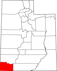

Dixie is a nickname for the populated, lower-elevation area of south-central Washington County, the southwest corner of the State of Utah. The area lies in the northeastern Mojave Desert, south of Black Ridge and west of the Hurricane Cliffs. Its winter climate is significantly more mild than the rest of Utah.
Originally settled by Southern Paiutes, the area became part of the United States after the Mexican–American War. In 1854, members of the Church of Jesus Christ of Latter-day Saints moved to the area to establish Brigham Young's intended Indian mission in the region.[1] After arrival, the settlers began growing cotton and other temperate cash crops in and around Santa Clara, Utah. By 1860, the Paiute population had declined due to disease from and displacement by the new settlers.[2][3]
Because of the warmer climate, the importance of cotton, and the origin of some early settlers, the area was nicknamed "Dixie,” referencing Dixie, the nickname for the southern states of United States that seceded and formed the Confederate States of America, which lost the American Civil War.
- ^ Bradshaw, Hazel; Jenson, Nellie (1978) [1950]. Under Dixie Sun: a History of Washington County. Daughters of Utah Pioneers Washington County Chapter. p. 23. OCLC 4831960.
- ^ Utah History To Go, Paiute Indians from historytogo.utah.gov accessed December 4, 2015.
- ^ Arrington, Leonard J. (August 1956). "The Mormon Cotton Mission in Southern Utah". Pacific Historical Review. 25 (3): 221–238. doi:10.2307/3637013. JSTOR 3637013.
© MMXXIII Rich X Search. We shall prevail. All rights reserved. Rich X Search
