Native name: Uummannap qeqertaa | |
|---|---|
 Location of Uummannaq Island | |
 | |
| Geography | |
| Location | Uummannaq Fjord |
| Coordinates | 70°42′11″N 52°08′00″W / 70.70306°N 52.13333°W |
| Area | 12 km2 (4.6 sq mi) |
| Highest elevation | 1,170 m (3840 ft) |
| Highest point | Uummannaq |
| Administration | |
Greenland | |
| Municipality | Avannaata |
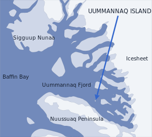
Uummannaq Island (Greenlandic: Uummannap qeqertaa[1]) is a small (12 km2 (4.6 sq mi))[1] island in Avannaata municipality in northwestern Greenland. Located in the south-central part of the Uummannaq Fjord, it is home to the most prominent mountain on the Arctic coast of western Greenland and to Uummannaq, the largest town north of Ilulissat.[2]
The island is separated from Nuussuaq Peninsula in the southwest by Sarqarput Strait in the southern arm of Uummannaq Fjord. In the east, the island is separated from the Salliaruseq Island by the wide Assorput Strait. To the north, the central arm of Uummannaq Fjord separates it from the large Appat Island and the skerries of Saattut.[3]
- ^ a b "Uummannaq" (in Kalaallisut). Avannaata Kommunia. 202. Retrieved 2023-12-18.
- ^ 'Greenland in Figures 2009', Statistics Greenland
- ^ Nuussuaq, Saga Map, Tage Schjøtt, 1992
© MMXXIII Rich X Search. We shall prevail. All rights reserved. Rich X Search
