Back نهر ڤيرد (نهر) ARZ Río Verde (Arizona) Spanish رودخانه ورده Persian Verde (rivière) French ורדה (נהר) HE Verde River Dutch Верде (приток Солта) Russian 佛得河 Chinese
| Verde River | |
|---|---|
 Near Clarkdale along Sycamore Canyon Road | |
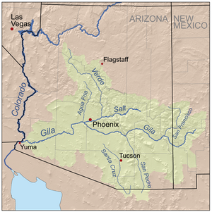
 Map of the Gila River watershed, including the Verde River | |
| Native name | Haka'he:la (Yavapai) |
| Location | |
| Country | United States |
| State | Arizona |
| County | Yavapai, Gila, Maricopa |
| Physical characteristics | |
| Source | Sullivan Lake |
| • location | near Paulden, Yavapai County |
| • coordinates | 34°51′50″N 112°27′39″W / 34.86389°N 112.46083°W[1] |
| • elevation | 4,354 ft (1,327 m)[2] |
| Mouth | Salt River |
• location | near Fountain Hills, Maricopa County |
• coordinates | 33°32′49″N 111°39′38″W / 33.54694°N 111.66056°W[1] |
• elevation | 1,325 ft (404 m)[1] |
| Length | 170 mi (270 km) |
| Basin size | 6,615 sq mi (17,130 km2) |
| Discharge | |
| • location | near Scottsdale, 1 mile (1.6 km) from the mouth[3] |
| • average | 602 cu ft/s (17.0 m3/s)[3] |
| • minimum | 0 cu ft/s (0 m3/s) |
| • maximum | 127,000 cu ft/s (3,600 m3/s) |
| Basin features | |
| Tributaries | |
| • left | Sycamore Creek, Oak Creek, Wet Beaver Creek, West Clear Creek, Fossil Creek, East Verde River |
| • right | Granite Creek |
| Type | Wild, Scenic |
| Designated | August 28, 1984 |
The Verde River (Yavapai: Haka'he:la) is a major tributary of the Salt River in the U.S. state of Arizona. It is about 170 miles (270 km) long[4] and carries a mean flow of 602 cubic feet per second (17.0 m3/s) at its mouth. It is one of the largest perennial streams in Arizona.[4]
- ^ a b c "Verde River". Geographic Names Information System. United States Geological Survey. February 8, 1980. Retrieved October 17, 2012.
- ^ Source elevation derived from Google Earth search using GNIS source coordinates.
- ^ a b "Water-Data Report 2011: 09511300 Verde River Near Scottsdale, AZ" (PDF). United States Geological Survey. Retrieved November 12, 2012.
- ^ a b "Verde River, Arizona". National Wild and Scenic Rivers System. Retrieved October 18, 2014.
© MMXXIII Rich X Search. We shall prevail. All rights reserved. Rich X Search