Vestre Gausdal Municipality
Vestre Gausdal herred | |
|---|---|
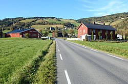
 View of the Bødalen area in Vestre Gausdal | |
 Oppland within Norway | |
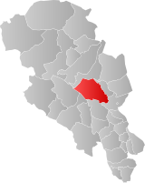
 Vestre Gausdal within Oppland | |
| Coordinates: 61°12′N 10°09′E / 61.2°N 10.15°E | |
| Country | Norway |
| County | Oppland |
| District | Gudbrandsdal |
| Established | 1879 |
| • Preceded by | Gausdal Municipality |
| Disestablished | 1 Jan 1962 |
| • Succeeded by | Gausdal Municipality |
| Administrative centre | Forset |
| Area (upon dissolution) | |
| • Total | 959 km2 (370 sq mi) |
| Population (1962) | |
| • Total | 2,590 |
| • Density | 2.7/km2 (7.0/sq mi) |
| Demonym | Gausdøl[1] |
| Time zone | UTC+01:00 (CET) |
| • Summer (DST) | UTC+02:00 (CEST) |
| ISO 3166 code | NO-0523[2] |
Vestre Gausdal is a former municipality in the old Oppland county, Norway. The 959-square-kilometre (370 sq mi) municipality[3] existed from 1879 until its dissolution in 1962. The area is now part of Gausdal Municipality. The administrative centre was the village of Forset.[4]
- ^ "Navn på steder og personer: Innbyggjarnamn" (in Norwegian). Språkrådet.
- ^ Bolstad, Erik; Thorsnæs, Geir, eds. (26 January 2023). "Kommunenummer". Store norske leksikon (in Norwegian). Kunnskapsforlaget.
- ^ Helland, Amund (1913). "Østre Gausdal herred". V Kristians amt. Tredie del. Norges land og folk (in Norwegian). Kristiania, Norway: H. Aschehoug & Company. p. 399. Retrieved 18 July 2022.
- ^ Thorsnæs, Geir, ed. (8 February 2022). "Vestre Gausdal (tidligere kommune)". Store norske leksikon (in Norwegian). Kunnskapsforlaget. Retrieved 18 July 2022.
© MMXXIII Rich X Search. We shall prevail. All rights reserved. Rich X Search
